I am making this blog into a video series. I am slowly adding the videos to this blog.
- INTRODUCTION: SIGNS OF ECONOMIC STRESSORS IN THE UNITED STATES FEDERAL GOVERNMENT
- 1. ECONOMIC STRESSORS THAT MAY LEAD TO DECENTRALIZATION OF THE UNITED STATES GOVERNMENT
- 2. CAVEATS REGARDING POSSIBLE LOCI OF SOCIAL UNREST
- 3. ON MAINTAINING A POSITIVE ATTITUDE IN THE FACE OF CHANGE
- 4. POSSIBLE FUTURE UNITED STATES ECONOMIC REGIONS AND TRADE REGIONS
- HIV-AIDS Pandemic Economic Stressor 1: One Eastern Economic Region Including the Southern States and the Eastern Seaboard
- HIV-AIDS Pandemic Economic Stressor 2: An Eastern Seaboard Economic Region and a Southern Economic Region
- Western Economic and Cultural Stressors: Northwest Economic Region and California Central Valley Economic Region
- Jade Helm Stressors: A Utah-Colorado Trade Region; a Texas Trade Region; a Mexican Trade Corridor; and a Florida-Caribbean Trade Corridor
- Southwestern Arid Region: Small Town and Native American Reservation Citadels
- Central Breadbasket Economic Region
- Possible Future Capital Cities of the United States
- 5. REGIONAL PACTS NOW IN PLACE
- 6. MORE INFORMATION
- 6.1 ECONOMIC AND HISTORICAL STRESSORS
- Civil War Historical Stressor
- Dust Bowl Economic Stressor
- Historical Expansion Stressor
- HIV-AIDS Pandemic Stressor
- Jade Helm Economic Stressor
- Rainfall – Aridity Economic Stressor
- 6.2 SURVIVAL FACTORS
- Nuclear Power Plants and Seismic (Earthquake) Safety Survival Factor
- Post-Nuclear-War Survival Factor
- 6.3 TRANSPORTATION
- Longest United States Hiking Trails
- Native American Trade Routes
- Railroad Lines
- 6.4 CAVEATS FOR UNITED STATES DOMESTIC TOURISTS
- 6.5 NEWS THAT SUPPORTS THE THEORY OF A TURN TOWARDS LIBERTARIANISM
- 6.1 ECONOMIC AND HISTORICAL STRESSORS
…
Dear Ones,
INTRODUCTION: SIGNS OF ECONOMIC STRESSORS IN THE UNITED STATES FEDERAL GOVERNMENT
First I have for you three signs of economic stressors in the United States Federal Government that I noticed …
- I read that the IRS plans to close three of its branch offices by the year 2024, leaving only its Ogden, Utah, and Kansas City, Missouri offices to process taxes … Link: “Ogden IRS Site One of Two Nationwide to Survive Closures,” by Cathy Mckitrick, 24 September 2016, in Standard-Examiner … https://www.standard.net/news/government/2016/sep/14/ogden-irs-site-one-of-two-nationwide-to-survive-closures/ ..
- Then I read in an article written for CNET by Katie Teague and Kelsey Fogarty on 14 September 2021 that the IRS might take 6 months (rather than the usual 3 weeks) to process the tax returns of about 10% of its taxpayers. Here is an update on the state of as-yet-unprocessed returns for tax year 2021 and a similar warning for tax return delays for tax year 2022 … Link: “Your Tax Return Might Be Delayed This Year, the IRS Warns,” by Alicia Adamczyk, 13 January 2022, in Make It … https://www.cnbc.com/2022/01/13/irs-warns-there-will-be-delays-processing-2021-tax-returns-and-refunds.html ..
- And finally, I read that the United States Post Office is cutting post office hours and lengthening delivery times in a new 10-year plan … Link: “USPS Chief Dejoy Cuts Post Office Hours, Lengthens Delivery Times in New 10-Year Plan,” by Jacob Bogage, 23 March 2021, in The Washington Post … https://www.washingtonpost.com/business/2021/03/22/usps-dejoy-plan/ ..
…
1. ECONOMIC STRESSORS THAT MAY LEAD TO DECENTRALIZATION OF THE UNITED STATES GOVERNMENT top
I have some thoughts on the state of the nation. Intuitively, I sense economic stressors that may gradually lead to our Federal government taking a lesser role in the governance of the United States, compared to the role of regional alliances of states.
Just to put this into perspective, this might be more of a Libertarian notion as a way of the ruling of the United States, still within the plan of our democracy, but rather different in emphasis from what we have known for a long time as the Democratic / Republican dichotomy.
All this time, Greenpeace and Libertarianism have been on our ballots, so we know they are a part of our democratic process. Only the look and feel of them is quite different, and it may cause us to wonder what is happening in the coming years.
In the coming times, I see the Federal government continuing to provide military defense, social security payments, and leadership in foreign affairs. I also see states taking more initiative in regard to economics for their regions.
As to trade, I see future reliance on established railroad routes and water routes such as the Mississippi River. I anticipate that, should there be a gradual lessening of Federal power, then there might be more trade within an economic region, and less trade globally and nationally.
As to finance, I see potential reliance on barter, with care not to place our financial assets in overseas locations. Local-employment-based credit unions may come into favor as regional savings repositories.
There may be more reliance on those economic sectors that hold strong during recessions … such as locally grown food, locally obtainable building materials, and water supplies not piped in over long distances.
As to economic stressors, I suggest the overarching stressor of the COVID-19 pandemic, the slowly building economic impact of the HIV pandemic, and stress of regional aridity due to long-distance water transport costs,
A socially disruptive stressor is handheld psychosis, which may lead to chaotic events such as mass murders and actions by public utilities, local law enforcement, and the military regarding perceived dangers that do not truly exist. This might precipitate social unrest, especially in regions of the United States pinpointed by the Jade Helm exercises.
…
2. CAVEATS REGARDING POSSIBLE LOCI OF SOCIAL UNREST top
In United States cities, the high cost of housing and the increasing phenomenon of homelessness may lead to social unrest and attempted land grabs through anarchist behavior; this is something for which, I feel, every large city mayor and every state government ought to have on hand emergency action plans.
For states in arid regions, emergency anti-anarchist plans ought, I feel, to highlight security of water transport systems. Electrical grids, I feel, might also be an anarchist target.
I have a few examples for you, state by state …
In California, I see a rekindling of the Latin American ideal of revolutionary ardor, with possible attempts by undocumented workers … or documented workers fleeing from crimes in their homelands under false names. These energies might, for instance, take the form of faking murders of homeowners under pretense of COVID deaths. The intent might be a fast flip of real estate for profit for a revolutionary cause. Or such an attempt might be made so as to charge revolutionaries rent on homes acquired through COVID murder. Such murders might take place under the aegis of religious righteousness … or what I might term leftwing terrorism.
In others of the United States, there may be similar energies of fake COVID deaths to espouse other causes, such as black militance, white supremacy, and so on.
In Utah, there might be a Mormon separatist energy because of the seditionist history I have read took place with the founder of Mormonism. (I read that in Wikipedia.)
In Florida, there might be attempts on political power by drug lords from countries to the south. And so on.
We people in large United States cities can be a big help in creating peaceful environments for our children by offering our law enforcement departments volunteer help through neighborhood watch programs.
…
3. ON MAINTAINING A POSITIVE ATTITUDE IN THE FACE OF CHANGE top
It seems unlikely to me that anything would happen in a moment; rather I feel that the United States might very slowly tend towards a model of government more akin to the state by state model of our early years as a nation. We may find, in future, that traveling from one state to the next is a refreshingly new experience. Not everyone may be watching the same thing on television every night anymore; there may be less airline flights from here to there; and so the natural flavor and local color of each region of the United States may become more striking to the casual tourist.
In addition, it may be that some regions of the United States may be more perilous (that is, more dangerous) for tourist travel, as was the case for travelers in the early years of our nation.
I realize the prospect of change can be unsettling. It is good to keep in mind that changes such as those spoken of … if, indeed, change there be … would in all likelihood take place by slow stages, over the course of the next century or two. Thus I feel certain there would be plenty of time to make our plans and find our footing in the new.
…
4. POSSIBLE FUTURE UNITED STATES ECONOMIC REGIONS AND TRADE REGIONS top
This section has a series of maps that I have adapted to show possible United States economic regions and trade regions of the centuries that are to come. I would be interested in your comments regarding this intriguing topic of the eventual possibility that the United States government might become less centralized, and more imbued with local flavor and with the strong spirit of our local communities.
HIV-AIDS Pandemic Economic Stressor 1: One Eastern Economic Region Including the Southern States and the Eastern Seaboard
The first map looks like this …

Image: “HIV Pandemic Economic Stressor 1: One Eastern Economic Region Including the Southern States and the Eastern Seaboard,” adapted by Alice B. Clagett, 6 December 2019, CC BY-SA 4.0 … DESCRIPTION: To the right of the white line, One Eastern Economic Region including the Southern states and the Eastern Seaboard … CREDIT: The topographic map is “USA topo en.jpg” [USA Topographical Map], from Wikimedia Commons …
DESCRIPTION: To the right of the white line, One Eastern Economic Region including the Southern states and the Eastern Seaboard …
CREDIT: The topographic map is “USA topo en.jpg” [USA Topographical Map], from Wikimedia Commons … https://commons.wikimedia.org/wiki/File:USA_topo_en.jpg … CC BY-SA 3.0 Unported
You can see a topographical map of the United States that also shows the aridity … the rainfall. States that are green have more rainfall; states that are yellow, less; and states that are red, very little rainfall. Then I have drawn a white line showing an economic region that includes the Eastern Seaboard and the Southern states.
These states are very much affected right now … more so than the other states … by the HIV and AIDS pandemic. And my thought was that that might act as a stressor that would consolidate that group of states into an economic region …
HIV-AIDS Pandemic Economic Stressor 2: An Eastern Seaboard Economic Region and a Southern Economic Region
This map encompasses the same general region as the prior map, but it is divided into two economic regions. To the right is the Eastern Seaboard, and to the bottom left, the Southern states. There is a yellow line between the two economic regions …

Image: “HIV Pandemic Economic Stressor 2: An Eastern Seaboard Economic Region and a Southern Economic Region,” adapted by Alice B. Clagett, 6 December 2019, CC BY-SA 4.0 … DESCRIPTION: To the right of the white line, the earlier Eastern Economic Region divided by the yellow line into two smaller regions: an Eastern Seaboard Region and a Southern Region … CREDIT: The topographic map is “USA topo en.jpg” [USA Topographical Map], from Wikimedia Commons … https://commons.wikimedia.org/wiki/File:USA_topo_en.jpg … CC BY-SA 3.0 Unported
DESCRIPTION: To the right of the white line, the earlier Eastern Economic Region divided by the yellow line into two smaller regions: an Eastern Seaboard Economic Region and a Southern Economic Region …
CREDIT: The topographic map is “USA topo en.jpg” [USA Topographical Map], from Wikimedia Commons … https://commons.wikimedia.org/wiki/File:USA_topo_en.jpg … CC BY-SA 3.0 Unported
So that would be two regions with their own special, local flavor, their own trade agreements; and maybe closely aligned with inter-region trade agreements.
Western Economic and Cultural Stressors: Northwest Economic Region and California Central Valley Economic Region
The below map deals with the West Coast. It shows two economic regions set apart from the rest of the United States with white lines. The upper one is the Northwest Economic Region, and the lower one is the California Central Valley Economic Region …

Image: “Western Economic and Cultural Stressors,” adapted by Alice B. Clagett, 6 December 2019, CC BY-SA 4.0 … DESCRIPTION: Along the Pacific Coast, two regions delineated by white lines. To the north is the Northwest Economic Region, including the parts of Washington state and Oregon with good rainfall. To the South is the California Central Valley Economic Region (also with good rainfall) … CREDIT: The topographic map is “USA topo en.jpg” [USA Topographical Map], from Wikimedia Commons … https://commons.wikimedia.org/wiki/File:USA_topo_en.jpg … CC BY-SA 3.0 Unported
DESCRIPTION: Along the Pacific Coast, two regions delineated by white lines. To the north is the Northwest Economic Region, including the parts of Washington state and Oregon with good rainfall. To the South is the California Central Valley Economic Region (also with good rainfall) …
CREDIT: The topographic map is “USA topo en.jpg” [USA Topographical Map], from Wikimedia Commons … https://commons.wikimedia.org/wiki/File:USA_topo_en.jpg … CC BY-SA 3.0 Unported
Jade Helm Stressors: A Utah-Colorado Trade Region; a Texas Trade Region; a Mexican Trade Corridor; and a Florida-Caribbean Trade Corridor
This is an interesting map. The Description is below the image …

Image: “Jade Helm Stressors: A Utah-Colorado Trade Region; a Texas Trade Region; a Mexican Trade Corridor; and a Florida-Caribbean Trade Corridor,” adapted by Alice B. Clagett, 6 December 2019, CC BY-SA 4.0 … DESCRIPTION: Circled in yellow are two possible regions that might secede from the Union, but with which reciprocal trade agreements might be negotiated. Topmost is a Utah-Colorado Trade Region (which might be divided into two separate areas based on dominant religion). Lower and to the right is a Texas Trade Region comprising what is now eastern, central, and northern Texas. Then there are two southern regions delineated in white. These are regions that might lean favorably towards alliance with Mexico, but with which we might anticipate establishing reciprocal trade agreements. To the left is a Mexican Trade Corridor comprising California from Los Angeles and to the south; the lower halves of Arizona and New Mexico, and the southwestern part of Texas. To the right is the state of Florida, which might lean favorably toward the Caribbean countries, but with which we might anticipate establishing reciprocal trade agreements; this I term the Florida-Caribbean Trade Corridor … CREDIT: The topographic map is “USA topo en.jpg” [USA Topographical Map], from Wikimedia Commons … https://commons.wikimedia.org/wiki/File:USA_topo_en.jpg … CC BY-SA 3.0 Unported
DESCRIPTION: Circled in yellow are two possible regions that might secede from the Union, but with which reciprocal trade agreements might be negotiated. Topmost is a Utah-Colorado Trade Region (which might be divided into two separate areas based on dominant religion). Lower and to the right is a Texas Trade Region comprising what is now eastern, central, and northern Texas.
Then there are two southern regions delineated in white. These are regions that might lean favorably towards alliance with Mexico, but with which we might anticipate establishing reciprocal trade agreements.
To the left is a Mexican Trade Corridor comprising California from Los Angeles and to the south; the lower halves of Arizona and New Mexico, and the southwestern part of Texas.
To the right is the state of Florida, which might lean favorably toward the Caribbean countries, but with which we might anticipate establishing reciprocal trade agreements; this I term the Florida-Caribbean Trade Corridor …
CREDIT: The topographic map is “USA topo en.jpg” [USA Topographical Map], from Wikimedia Commons … https://commons.wikimedia.org/wiki/File:USA_topo_en.jpg … CC BY-SA 3.0 Unported
As to the Utah-Colorado Trade Region: In Utah, the Mormon faith is very strong. And in Colorado, the Christian faith is very strong. I thought that those two areas of this economic region might pull separately apart, possibly along religious lines.
Southwestern Arid Region: Small Town and Native American Reservation Citadels
This is an interesting map. There is a Description below the image …

Image: “Southwestern Arid Region: Small Town and Native American Reservation Citadels,” adapted by Alice B. Clagett, 6 December 2019, CC BY-SA 4.0 … DESCRIPTION: Circled in white is the large Southwestern Arid Region, which might move to more local forms of small town government … as well as continuing with Native American Reservation governments … should the nation become less centralized. This economic region includes the Great Basin, the Great Rocky Mountains, and the western portion of the Great Plains … CREDIT: The topographic map is “USA topo en.jpg” [USA Topographical Map], from Wikimedia Commons … https://commons.wikimedia.org/wiki/File:USA_topo_en.jpg … CC BY-SA 3.0 Unported
DESCRIPTION: Circled in white is the large Southwestern Arid Region, which might move to more local forms of small town government … as well as continuing with Native American Reservation governments … should the nation become less centralized. This economic region includes the Great Basin, the Great Rocky Mountains, and the western portion of the Great Plains …
CREDIT: The topographic map is “USA topo en.jpg” [USA Topographical Map], from Wikimedia Commons … https://commons.wikimedia.org/wiki/File:USA_topo_en.jpg … CC BY-SA 3.0 Unported
This area of the country is very, very arid. One can tell that by the color. I have cordoned off this entire arid zone as an area where Native Americans may establish reservation ‘citadels’ or ‘city towns’ that might act as trading posts for the area, for instance. I consider that they would become more like ‘city states’ if transportation slows down in the United States, and especially in that area, over the centuries.
Central Breadbasket Economic Region
On this map, the area in question is rather green. There is a little yellow, so that part is a little more arid land. It comprises the United States to the west and to the south of the Great Lakes. It includes most of the Mississippi River Valley as well. It looks like this …

Image: “Central Breadbasket Economic Region,” adapted by Alice B. Clagett, 6 December 2019, CC BY-SA 4.0 … DESCRIPTION: Circled in green is a Central Breadbasket Economic Region, with plentiful rainfall and good river transportation. This includes the eastern portion of the Great Plains, as well as the area south of the Great Lakes, west of the Appalachians, and north of the Southernmost states … CREDIT: The topographic map is “USA topo en.jpg” [USA Topographical Map], from Wikimedia Commons … https://commons.wikimedia.org/wiki/File:USA_topo_en.jpg … CC BY-SA 3.0 Unported
DESCRIPTION: Circled in green is a Central Breadbasket Economic Region, with plentiful rainfall and good river transportation. This includes the eastern portion of the Great Plains, as well as the area south of the Great Lakes, west of the Appalachians, and north of the Southernmost states …
CREDIT: The topographic map is “USA topo en.jpg” [USA Topographical Map], from Wikimedia Commons … https://commons.wikimedia.org/wiki/File:USA_topo_en.jpg … CC BY-SA 3.0 Unported
We can anticipate that, if this continues to be a breadbasket area, it could provide food for other economic regions in the United States; and therefore, we would need to maintain some form of transportation to the south and to the east of the Central Breadbasket Region. The question would be whether transportation might be maintained across that vast, arid expanse to the west of the Breadbasket; or whether the Western Seaboard would need to grow its own foodstuffs as transportation became less prevalent.
Possible Future Capital Cities of the United States
Here is the last section, and an interesting one. I have for you three possibilities labeled 0, 1 and 2. The first is Washington, D.C., numbered ‘0’, because that is where the capital of the United States is right now.
Next is Lancaster, Pennsylvania, labeled ‘1’. Long ago, our nation’s capital was Lancaster; so I thought, perhaps one day our capital will be there once more.
And the last is Saint Louis, Missouri, labeled ‘2’. Saint Louis is right in the middle of the Breadbasket. I suggested Saint Louis as the second possibility because the location would be more centralized, and it might pull the other regions together.

Image: “Possible Future Capital Cities of the United States,” adapted by Alice B. Clagett, 6 December 2019, CC BY-SA 4.0 … DESCRIPTION: The current capital of the United States is Washington DC (numbered ‘0’ on the map). Because of the AIDS crisis in Washington DC, and because our nation’s capital was once Lancaster PA, I suggest eventual relocation of the Capital back to Lancaster (numbered ‘1’ on the map). Farther out in time, it may be that Saint Louis, MO (labeled ‘2’) would prove a good location for our nation’s capital … CREDIT: The topographic map is “USA topo en.jpg” [USA Topographical Map], from Wikimedia Commons … https://commons.wikimedia.org/wiki/File:USA_topo_en.jpg … CC BY-SA 3.0 Unported
DESCRIPTION: The current capital of the United States is Washington DC (numbered ‘0’ on the map). Because of the AIDS crisis in Washington DC, and because our nation’s capital was once Lancaster PA, I suggest eventual relocation of the Capital back to Lancaster (numbered ‘1’ on the map). Farther out in time, it may be that Saint Louis, MO (labeled ‘2’) would prove a good location for our nation’s capital …
CREDIT: The topographic map is “USA topo en.jpg” [USA Topographical Map], from Wikimedia Commons … https://commons.wikimedia.org/wiki/File:USA_topo_en.jpg … CC BY-SA 3.0 Unported
…
5. REGIONAL PACTS NOW IN PLACE top
In the event of decentralization here in the United States, I feel the United States might expect to enjoy three power blocks along geographic lines of the three COVID pacts now in place amongst states in the Eastern States, the Midwest, and the Western States …
The Eastern States Multistate Council to do with COVID consists of the states of Connecticut, Delaware, Massachusetts, New York, New Jersey, Pennsylvania, and Rhode Island …
Link: “Eastern States Multi-State Council,” in English Wikipedia … https://en.wikipedia.org/wiki/Eastern_States_Multi-state_Council ..
As well, there is the Midwest Governors Regional Pact” to do with COVID. This consists of the states of Illinois, Indiana, Kentucky, Michigan, Minnesota, Ohio, and Wisconsin …
Link: “Midwest Governors Regional Pact,” in English Wikipedia … https://en.wikipedia.org/wiki/Midwest_Governors_Regional_Pact ..
There is also, to do with COVID, a Western States Pact involves the states of California, Colorado, Nevada, Oregon, and Washington …
Link: “Western States Pact and Possible Decentralization of the United States,” in English Wikipedia … https://en.wikipedia.org/wiki/Western_States_Pact#:~:text=The%20Western%20States%20Pact%20is,to%20the%20COVID%2D19%20pandemic. ..
Here is the map of the power blocks for these pacts, which, I feel, may well be expanded to assure continuity of taxation, mail delivery services, securance of real property rights, and local military defense, in the event of decentralization of the United States …

Image: “U.S. States Forming Pacts to Reopen the Economy (Coronavirus Pandemic),” by JayCoop, in Wikimedia Commons, 27 April 2020 … https://commons.wikimedia.org/wiki/File:U.S._states_forming_pacts_to_reopen_the_economy_(coronavirus_pandemic).svg … CC BY-SA 4.0 International
Image: “U.S. States Forming Pacts to Reopen the Economy (Coronavirus Pandemic),” by JayCoop, in Wikimedia Commons, 27 April 2020 … https://commons.wikimedia.org/wiki/File:U.S._states_forming_pacts_to_reopen_the_economy_(coronavirus_pandemic).svg … CC BY-SA 4.0 International
. . . . .…
In love, light and joy
This is Alice B. Clagett.
I Am of the Stars … and so are you!
Blog written and published on 6 December 2019; revised and updated on 2 October 2024; video filmed on 23 February 2022 and published on 26 February 2022 and following
Prior titles: What If the United States Became Less Federal and More Regional in Government? and What If: Will the United States Become Less Centralized?
See also … Link: “Western States Pact and Possible Decentralization of the United States,” by Alice B. Clagett, written and published on 2 June 2020 … https://wp.me/p2Rkym-is3 ..
6. MORE INFORMATION top
Below are maps I studied while writing this blog …
…
6.1 ECONOMIC AND HISTORICAL STRESSORS top
Civil War Stressor

Image: “United States map of 1861, showing affiliation of states and territories regarding secession from the Union at the start of the American Civil War,” by Júlio Reis, 23 February 2007, from English Wikipedia … https://en.wikipedia.org/wiki/File:US_Secession_map_1861.svg … CC BY-SA 3.0.
Image: “United States map of 1861, showing affiliation of states and territories regarding secession from the Union at the start of the American Civil War,” by Júlio Reis, 23 February 2007, from English Wikimedia … https://en.wikipedia.org/wiki/File:US_Secession_map_1861.svg … CC BY-SA 3.0.
Dust Bowl Economic Stressor

Image: Map of states and counties affected by the Dust Bowl [1930s], sourced from US federal government dept. (NRCS SSRA-RAD).svg … “Based only on that PNG image. I made this file primarily using QGIS, and the following public domain … https://www.census.gov/geo/maps-data/data/tiger-cart-boundary.html shapefiles from census.gov] by Soil Science and Resource Assessment, Resource Assessment Division (NRCS SSRA-RAD) (Division of the U.S. Dept. Of Agriculture), 15 January 2012, from Wikimedia Commons … This work is in the public domain in the United States because it is a work prepared by an officer or employee of the United States Government as part of that person’s official duties under the terms of Title 17, Chapter 1, Section 105 of the US Code.
Historical Expansion Stressor

Image: “A Map of the United States Showing Land Claims and Cessions from 1782 to 1802,” by Kmusser, in Wikimedia Commons … https://en.wikipedia.org/wiki/State_cessions#/media/File:United_States_land_claims_and_cessions_1782-1802.png … CC BY-SA 2.5 Generic … DESCRIPTION: This is a map showing state land claims and cessions from 1782-1802 that I made. The disputed territory between New Hampshire and New York formed, in 1777, the independent country of ‘New Connecticut’ (later renamed ‘Vermont’) which eventually gained admission as the 14th state in 1791. Boundary disputes between states that were resolved before U.S. independence are not shown.
Image: “A Map of the United States Showing Land Claims and Cessions from 1782 to 1802,” by Kmusser, in Wikimedia Commons … https://en.wikipedia.org/wiki/State_cessions#/media/File:United_States_land_claims_and_cessions_1782-1802.png … CC BY-SA 2.5 Generic
DESCRIPTION: This is a map showing state land claims and cessions from 1782-1802 that I made. The disputed territory between New Hampshire and New York formed, in 1777, the independent country of ‘New Connecticut’ (later renamed ‘Vermont’) which eventually gained admission as the 14th state in 1791. Boundary disputes between states that were resolved before U.S. independence are not shown.

Image: “perry-castenada: Admission of States and Territorial Acquisition U.S. Bureau of the Census (341K) http://www.lib.utexas.edu/maps/histus.html …” by United States Census Bureay, U.S. Government, circa 1970s … https://en.wikipedia.org/wiki/Territorial_evolution_of_the_United_States#/media/File:Territorial-acquisition-uscensus-bureau.jpg … public domain … DESCRIPTION: Census Bureau map depicting territorial acquisitions and dates of statehood, probably created in the 1970s.
Image: “perry-castenada: Admission of States and Territorial Acquisition U.S. Bureau of the Census (341K) http://www.lib.utexas.edu/maps/histus.html …” by United States Census Bureay, U.S. Government, circa 1970s … https://en.wikipedia.org/wiki/Territorial_evolution_of_the_United_States#/media/File:Territorial-acquisition-uscensus-bureau.jpg … public domain …
DESCRIPTION: Census Bureau map depicting territorial acquisitions and dates of statehood, probably created in the 1970s.
HIV-AIDS Pandemic Stressor

Image: “Map infographic displaying rates of HIV Diagnosis in the United States based on 2017 CDC data, published by the CDC in February of 2019,” United States Centers for Disease Control, 1 February 2019, Source: https://www.cdc.gov/hiv/images/statistics/overview/geography/hiv-us-map-2017.png … in Wikimedia Commons … https://commons.wikimedia.org/wiki/File:Hiv-us-map-2017.png … public domain
Image: “Map infographic displaying rates of HIV Diagnosis in the United States based on 2017 CDC data, published by the CDC in February of 2019,” United States Centers for Disease Control, 1 February 2019, Source: https://www.cdc.gov/hiv/images/statistics/overview/geography/hiv-us-map-2017.png … in Wikimedia Commons … https://commons.wikimedia.org/wiki/File:Hiv-us-map-2017.png … public domain
Jade Helm Economic Stressor

Image: “U.S. Army Special Operations Command map, depicting the US military plans during the Jade Helm 15 exercise,” by U.S. Army Special Operations Command, 31 March 2015, Source: https://www.washingtonpost.com/news/checkpoint/wp/2015/03/31/why-the-new-special-operations-exercise-freaking-out-the-internet-is-no-big-deal/ … This image is a work of a U.S. Army soldier or employee, taken or made as part of that person’s official duties. As a work of the U.S. federal government, the image is in the public domain.
Image: “U.S. Army Special Operations Command map, depicting the US military plans during the Jade Helm 15 exercise,” by U.S. Army Special Operations Command, 31 March 2015, Source: https://www.washingtonpost.com/news/checkpoint/wp/2015/03/31/why-the-new-special-operations-exercise-freaking-out-the-internet-is-no-big-deal/ … This image is a work of a U.S. Army soldier or employee, taken or made as part of that person’s official duties. As a work of the U.S. federal government, the image is in the public domain.
The above map leaves out Florida, Louisiana, and Mississippi, which were mentioned as being part of the Jade Helm 15 exercise here: “The joint exercise in realistic military training (RMT) known as Jade Helm 15 … was sponsored by the United States Special Operations Command (USSOCOM or SOCOM) … and involved the United States Army Special Operations Command (USASOC) and Joint Special Operations Command (JSOC) with other U.S. Military units in multiple states, including Texas, Arizona, Florida, Louisiana, Mississippi, New Mexico, and Utah.” –from Link: “Jade Helm 15 conspiracy theories,” in Wikipedia … https://en.wikipedia.org/wiki/Jade_Helm_15_conspiracy_theories ..
This map of the Jade Helm exercises includes the states missing in the map above … Link: “Other information (unconfirmed) suggests that Jade Helm is geographically larger (10 states), involves larger forces and has already started,” in Citizens Journal … https://www.citizensjournal.us/wp-content/uploads/2015/05/jadehelmother.jpg ..
Rainfall – Aridity Economic Stressor

Image: “USA topo en.jpg” [USA Topographical Map], from Wikimedia Commons … https://commons.wikimedia.org/wiki/File:USA_topo_en.jpg … CC BY-SA 3.0 Unported
…
6.2 SURVIVAL FACTORS top
Nuclear Power Plants and Seismic (Earthquake) Safety Survival Factor
Image: “Map prepared for CRS report for Congress: Andrews, Anthony, 2011 ‘Nuclear power plant design and seismic safety considerations’ Library of Congress Congressional Research Service report R41805, May 2, 2011, Washington. p. 22, fig. 8.” Available also through the Library of Congress Web site as a raster image. Includes list of nuclear reactors with statistics. 2011. Source: https://www.loc.gov/item/2011594649/ … from Wikimedia Commons … https://commons.wikimedia.org/wiki/File:Operating_nuclear_power_plant_sites_vs._seismic_hazards_in_terms_of_percent_gravitational_acceleration_-_(United_States)_LOC_2011594649.jpg …. This work is in the public domain in the United States because it is a work prepared by an officer or employee of the United States Government as part of that person’s official duties under the terms of Title 17, Chapter 1, Section 105 of the US Code.
Image: “Map prepared for CRS report for Congress: Andrews, Anthony, 2011 ‘Nuclear power plant design and seismic safety considerations’ Library of Congress Congressional Research Service report R41805, May 2, 2011, Washington. p. 22, fig. 8.” Available also through the Library of Congress Web site as a raster image. Includes list of nuclear reactors with statistics. 2011. Source: https://www.loc.gov/item/2011594649/ … from Wikimedia Commons … https://commons.wikimedia.org/wiki/File:Operating_nuclear_power_plant_sites_vs._seismic_hazards_in_terms_of_percent_gravitational_acceleration_-_(United_States)_LOC_2011594649.jpg …. This work is in the public domain in the United States because it is a work prepared by an officer or employee of the United States Government as part of that person’s official duties under the terms of Title 17, Chapter 1, Section 105 of the US Code.
Post-Nuclear-War Survival Factor
Link: “The effects of a theoretical nuclear war in the USA – includes fallout, power outages, relief efforts, and more,” in Reddit … https://external-preview.redd.it/xyL0-MpSdZbu794s_N3NtCzySubUaitc9MoGcv_i7b0.jpg?auto=webp&s=c4630e18ef94d0ddf0c5759d3cf5d93222fcc9e4 ..
…
6.3 TRANSPORTATION top
Longest United States Hiking Trails
My feeling is, these hiking trails might provide alternative transportation routes if highways are blocked due to natural disasters or highway repair issues …
Image: “Long Distance Hiking Trails in U.S.,” by ZeroGram … https://cdn.imweb.me/upload/S201905065ccffe1baee08/5c94f72b9fa12.jpg ..
Link: “Long-Distance Trails in the United States,” by English Wikipedia … https://en.wikipedia.org/wiki/Long-distance_trails_in_the_United_States ..
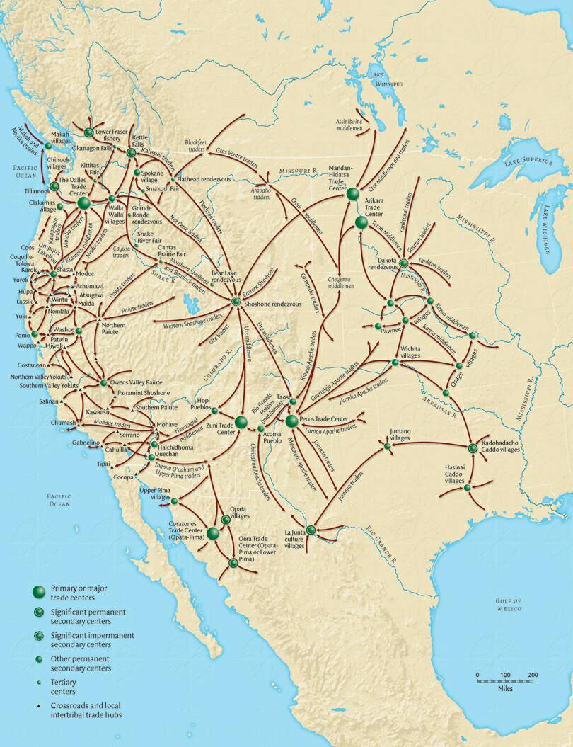
Native American Trade Routes
I thought these Native American trade routes must represent terrain more easily traversible on foot or ahorse …
Image: “Smithsonian Institution map of native American trade routes through a little of Mexico, some of Canada and the United States” … https://pbs.twimg.com/media/DNFnMn-XUAAXDqH.jpg ..
Railroad Lines

Image: “This is a map of the Class I Railroads I made using DOT data,” by Kmusser, 9 August 2006, in Wikimedia Commons. This file is licensed under the Creative Commons Attribution-Share Alike 2.5 Generic license.
Image: “This is a map of the Class I Railroads I made using DOT data,” by Kmusser, 9 August 2006, in Wikimedia Commons. This file is licensed under the Creative Commons Attribution-Share Alike 2.5 Generic license.
…
6.4 CAVEATS FOR UNITED STATES DOMESTIC TOURISTS top
It may become more difficult to travel from state to state; this may have to do with lack of availability of gasoline, or lack of availability of charging stations for electric cars.
United States tourists may find it less safe to travel to other states. Their lives may even be imperiled while staying in some small towns that are distant from their own residences.
There may be tampering on a local basis with criminal databases, combined with identity theft and synthetic identity fraud, so that a tourist to a small town in a distant state is fraudulently classed as a criminal, and then subjected to local laws whose flavor and whose meeting of criminal punishment differs greatly from those in the tourist’s home town.
For instance, in the visited town euthanasia of senior citizens might be legal. The ‘captured’ tourist might be legally executed on a charge of senile dementia or Alzheimer’s disease. That charge could be made to stick through unrelated, criminal local people swearing on oath that the person is their spouse, swearing that the age is elderly, stating that the person has no money or means of earning it. Then the tourist might be killed and his or her money divvied up amongst the judge and the perjuring criminal.
Other instances: Blue laws and the penalties for child molestation, and the enforcement of these laws differ greatly from state to state. It is easy to assume that what ‘flies’ in one’s own state will ‘fly’ in the tourist town. Then, quick as a whip, a person might find himself behind bars and far from home, and subject to whatever local scam will fleece him of his money.
Another instance: Drug possession laws differ greatly from state to state. The scenario is the same as for Blue laws.
Drug lords may be in possession of the town, as was the case with Baltimore, Maryland, in recent years. If so, anything goes. Best not to set foot there. It is possible that local law enforcement and local court systems in towns ‘captured’ by drug lords might function in ways unexpected by a tourist, because of the threat of death for themselves and their families, and also because of financial inducements by drug lords. In other words, the tourist’s life might be worth a nickel. Maybe less.
A local tradition of bribery of officials is a consideration for tourists. This horse kicks two ways: You might be jailed if you do not bribe; or you might be fined for attempting to bribe. I am at a loss for words here.
Other instances: Homelessness may be considered a cause for euthanasia without court trial. This stance might be set in place by barring a tourist from local motels and hotels, then accosting him or her while asleep in their car.
Suppose a local gas fill-up were to result in a car breakdown 10 miles away, say, in the desert. Suppose the gas station owner had a group of related men who went out to scavenge vehicle parts, wallet and credit cards of the stranded car owner, and leave his bones beneath a Joshua tree.
[In terms of unexpected services rendered, I have encountered a case a little like that here in Los Angeles, where an acupuncturist demanded to see the drivers license after treatment, as a prerequisite to payment for services rendered. I intuited that the health care practitioner has an expensive addiction, and had been sending round family members to the addresses on the drivers licenses of her clients to burglarize the homes to help finance her habit. To prevent the victims from returning … in other words, to ensure a fresh group of people to be burgled … the acupuncturist set the electric needle settings too high, so that her clients received muscle-stunning electric shocks from the needles.]
The tourist’s sanity may be placed in doubt through false testimony by local mail-order psychologists also claiming at the local police station to be the ‘spouse’. This may be a game with many innings.
I intuit that local sheriffs and judges place more weight on testimony of their friends and neighbors than they do on the testimony of strangers. Where you visit, if you travel alone, may have crime gangs that, in cahoots with a sheriff or law enforcement officer, railroading tourists with intent to gain more tourist dollars. This may be more likely in low per capita towns.
There may be a local tradition of kangaroo courts that convict a tourist of this or that without his or her presence in the courtroom. There may be other legal irregularities, such as a crooked judge who holds a kangaroo court session on a Sunday, with written judgment conveyed, but with no online record of a court case. The kangaroo court paper of the crooked judge might be used to ‘capture’ and shake down the tourist. There is a danger of legal murder by euthanasia after the shake down, so as to prevent the tourist from taking legal action against the offending parties after changing the venue to their own home town.
In other words, the law may not be on your side, or it may not take the stance you expect it to take, when you travel to another state. This may become increasingly true with time, that towns in states other than one’s own may prove lethally unfriendly to tourists.
…
6.4 NEWS THAT SUPPORTS THE THEORY OF A RETURN TO LIBERTARIANISM top
I may be adding to this category as I run across news articles.
Unfriendliness of one state towards the residents of another state … Link: “Utah Governor Tells Californians to ‘Stay in California’,” by Alexandra E. Petri, 13 February 2023 … https://www.latimes.com/california/story/2023-02-13/utah-governor-tells-californians-to-stay-in-california ..
…………..
![]()
This work is licensed under a Creative Commons Attribution-ShareAlike 4.0 International License (CC BY-SA 4.0). Attribution: By Alice B. Clagett.
More license information
…………………………………………………….
…………………………………………………….
United States, government, economics, history, geography, politics, social unrest, Jade Helm, community health, HIV pandemic, AIDS pandemic, homelessness, handheld psychosis, my favorites, future, COVID-19, coronavirus, Libertarianism, democracy, trade, finance, economy, transportation,
Libertarianism, government, U.S. Government, United States government, United States, economy, economics, taxes, IRS, U.S. Post Office, communications, internal revenue service, decentralization,
United States, economy, economics, government, U.S. Government, United States government, decentralization, regionalism, Libertarianism, democracy, libertarianism, military, social security, foreign affairs, trade, transportation, finance, credit unions, handheld psychosis, law enforcement, public utilities, mass murder, social unrest, cognitive dysfunction, discernment,
social unrest, United States, housing, real estate, homelessness, government, state governments, city governments, water transport, utilities, electric utilities, anarchy, California, Utah, Florida, sedition, anarchy, murder, COVID, terrorism, leftwing terrorism, rightwing terrorism, racial tensions, cultural tensions, drug war, neighborhood watch, law enforcement, secret service,
United States, government, libertarianism, state governments, tourism, decentralization,
United States, government, libertarianism, state governments, trade, transportation, decentralization, trade agreements, Southern states, Eastern Seaboard, Western Seaboard, Mexican border, Native Americans, AIDS, HIV, Breadbasket, foodstuffs, agriculture,

.svg)
_LOC_2011594649.jpg)